
Hi, here you can download APK file "com.highsierraattitude.trthikerdemo" for free, apk file version is 7.2.00 to download to your android just click this button. It's easy and warranty. We provide only original apk files


Please download "Guthook Guides: Hike & Bike Offline" to access the Tahoe Rim Trail guide. Existing customers may transfer their purchases to the Guthook Guides: Hike & Bike Offline app. This app is no longer supported and will be removed from the Play Store October 2019.
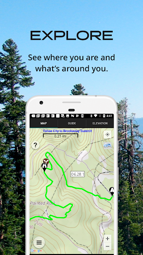
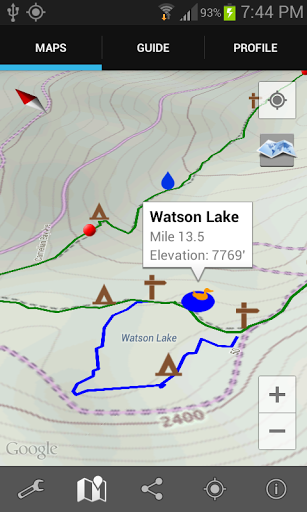
The Tahoe Rim Trail Guide is the official map-based navigational guide for the Tahoe Rim Trail Association. It maps and lists over 500 important hiker waypoints along the 173-mile TRT, such as water sources, tenting sites, road crossings, detailed resupply information, and many more.
The free demo for the Tahoe Rim Trail covers the 20.3-mile Tahoe City North Trailhead to Brockway Summit section of the Tahoe Rim Trail.
Key features:
- No mobile or internet connection is required after initial setup -- works in Airplane Mode
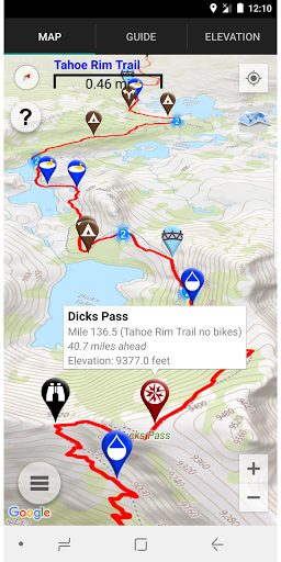
- Detailed maps with your GPS location
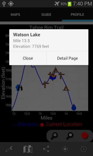
- Elevation profile view
- Custom route creator
- Multiple offline map choices
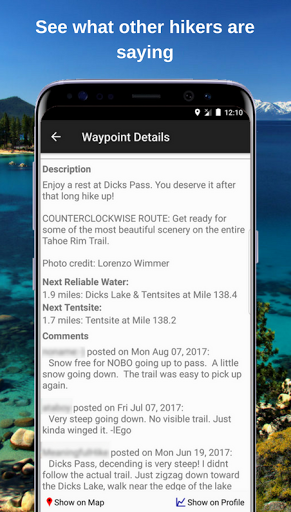
- Real-time comments from other hikers
- Send your current location to friends or family via text message or email
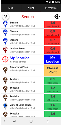
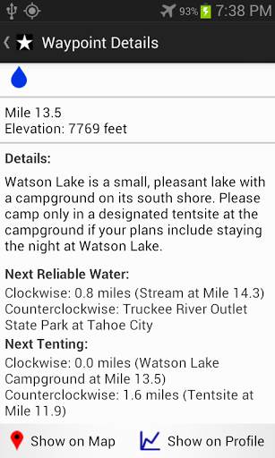
The guidebook lists every waypoint in order by distance along the trail and how far away you are from each waypoint. The guidebook also includes a detailed town guide for major resupply points, towns, and services along the TRT.
Waypoint details include:
- Mileage point and elevation
- Photographs
- Distance to the next water source and tent site
- Comments section where you may post comments and read other hikers’ comments
Types of waypoints:
- Water sources (including the reliability of each water source)
- Detailed resupply and town information:
- post offices and other package services
- restaurants
- grocery stores and convenience stores
- gear shops and hardware stores
- laundromats
- lodging, public showers, public restrooms
- public libraries
- Tenting sites/camping sites
- Trail junctions
- Parking areas along the trail
- Picnic areas, campgrounds, ranger stations
- Roads, railroad tracks, power lines, fences, gates
- Natural landmarks (e.g. mountain passes)
- Privies/restrooms
- Views
About the Tahoe Rim Trail: The Tahoe Rim Trail is a 173-mile trail that circles beautiful Lake Tahoe in the Sierra Nevada mountain range. The trail passes through California (113.5 miles) and Nevada (59.5 miles). 50 miles of the trail overlap the Pacific Crest Trail and 31 miles overlap the Tahoe-Yosemite Trail. The trail is broken into 8 sections, ranging from 17 miles to 32 miles each. Many hikers complete the entire Tahoe Rim Trail all at once while others complete the trail section by section. Countless others enjoy day-hiking and mountain biking the trail.
Tahoe Rim Trail, TRT


